 The gas line is an 8 mile North-South scar across the heart of Rothrock State Forest. It goes from near Colyer Lake in the North to Big Valley in the area of Barrville in Mifflin County in the South. Anyone who has done much hiking, or even driving, in the area has enjoyed the vistas it provides. And anyone with any interest in human powered adventures instantly sees possibilities in a 30-yard wide trail constructed with complete disregard to topography. The simplest of these would be to simply start at one end, hike to the other, and hike back. That was my plan last Saturday on a beautiful, sunny winter Saturday.
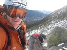
I packed up on Friday. I didn't take much but I brought along my down jacket as a bit of insurance against a night out in the low teens, my gaiters as a hedge against overgrown brush, and extra ibuprofen as a precaution against knee problems. The down jacket required that I use my wife's GoLite Jam rather than my slick little 20L Cilogear leaderpack. I also pulled out my thin, lightweight hooded Marmot Ion windshirt to use as my shell to see how it performs in the cold (very well it turns out, but the real problem is it's just a bit too short to stay tucked in under my harness. I'll have to add a few clips or something). Unfortunately, I debated it, but left my trekking poles at home. I could have used them on the icey descents with creakey knees.


With a few hours of sleep after The Hangover, I was on the road around 5:00 am. Got some good sugary coffee for the ride. I wasn't exactly sure if I would be able to easily access the pipeline at the very edge of the northern state forest border. A few turnarounds in folks' driveways and I decided to bail to the back-up spot: the intersection of the pipeline with Treaster Kettle Road.
It was still totally dark when I got there so I chilled a bit in the Tacoma Lodge but got antsy and split with a bit of lighter sky in the east at 6:45. It was colder than I expected: 14 degrees. It took twenty minutes to go the first 50 yards as the stream through the gas line was just barely too big to jump and just barely to deep to wade wi th dry feet. So the only option was a heinouse bushwhack stream crossing through thick Mountain Laurel. Every other stream crossing was cake.
 th dry feet. So the only option was a heinouse bushwhack stream crossing through thick Mountain Laurel. Every other stream crossing was cake.
As day broke, the first mile or so is an easy grade and it feels odd to have so much space around you in the middle of the mountains of Central PA. No "green tunnel" here. It looks like PA, but feels like Wyoming. I was thinking it would be some nice cross-country skiing and eventually did see some ski tracks further on. I probably need skis.
The view from Thickhead mountain, south across Detwiler Run and the Mid-State Trail to Grass Mountain is one of the best. A deep, steep-sided valley without a road at the bottom. My knees start reminding me of why I hate long, steep, rocky downhills. This does not bode well.
Once I get to the top of Grass Mountain, the view south as the gas line makes a few turns to wind it's way through some convoluted ridges is amazing. I wake up a nice wilderness hobo spending "January" in Rothrock as part of the off-season from his farm job in southern Huntingdon county.  Nice guy. Very knowledgeable about the trails in the area and we chat some more on the way back through. Usually when I get this view I'm just crossing the gas line on some trail and it feels good to finally be walking it. Actually, it feels terrible because my knees are definetely in some pain by the bottom. The nice part of this is, the view from the bottom UP the mountain is as nice as the view DOWN. But the next stretch is kinda rolling and I continue on to gain the far ridge of Broad Mountain, seeing 8 turkeys on the way.
 Nice guy. Very knowledgeable about the trails in the area and we chat some more on the way back through. Usually when I get this view I'm just crossing the gas line on some trail and it feels good to finally be walking it. Actually, it feels terrible because my knees are definetely in some pain by the bottom. The nice part of this is, the view from the bottom UP the mountain is as nice as the view DOWN. But the next stretch is kinda rolling and I continue on to gain the far ridge of Broad Mountain, seeing 8 turkeys on the way.
I start down past Rag Hollow Road, but it's clear that my knees will probably sore for weeks and I have my CrossFit Level 1 cert in 6 days, so I turn around sometime before 11:00 and loaf it back to the truck under blue bird skies and warming weather. The snow-covered northern slopes of Grass and Thickhead were incredibly slick with the warmer weather. Just the surface had melted in the shade so it was too hard to edge or plunge step. I could have definetely used my trekking poles... both for my knees and for those descents. I also ran into two other backpackers off the MST on the way back. Good to see people getting out.

After 6588 feet total elevation, 12 miles, 9 hours, 8 turkeys, 4 squirrels, 3 hikers, and 1 itinerant wilderness hobo, I was definetely ready for my truck and a good home-grilled, double cheeseburger with provolone, salami, sauteed onions, and bacon.
No comments:
Post a Comment